|
The Yorkshire Dales is a region of North West Yorkshire in the North of England. The Yorkshire Dales National Park's valleys, cliffs, hills and moorland offer incredible walking and cycling. You can stay in a village Bed & Breakfast, visit stalactite covered caves, or see Bolton Abbey. There are old market towns like Grassington and Skipton, and famous waterfalls like Thornton Force. |
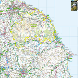
Map of the Yorkshire Dales including:
- Yorkshire Dales National Park
- Swaledale, Wensleydale, Nidderdale, Wharfedale, Littondale.
- Kirby Lonsdale, Settle, Skipton, Ilkley, Harrogate, Ripon, Richmond, Barnard Castle, Brough.
- Malham, Ingleborough, Pen-y-Ghent, Hawes, Grassington, Pateley Bridge, Bolton Abbey.
- The Pennine Way.
- The M6 Motorway, A66 Trunk Road, A1 to Scotch Corner.
|
This map is useful for:
- Tourist Information and Sightseeing.
- Hotel Holidays or Short Breaks.
- Yorkshire Dales Cottage Holidays.
- Route Planning.
- Activity Planning such as Rock Climbing, Cycling, Hiking and Walking.
- Download and view this map offline on your PC, Laptop, iPad, iPhone or Android Mobile Phone or Tablet.
|
|
|
|
|
|
|
|
|
|